Khomas
Ordna visum vid ankomst- Kod:KH
- Typ:region
- Folkmängd:342 141 (2011)
- Yta:37 007 km²
- Huvudort:Windhoek
Introduktion
Khomas is the small central-Namibian region built around the capital Windhoek and the surrounding Khomas Hochland — the mountainous plateau rising to 2 000 m that gives the region its name. It is geographically among the smallest of Namibia's fourteen regions (37 000 km²) but demographically the largest, with about 500 000 of the country's 2.6 million people living within its borders — almost all of them in Greater Windhoek. The region is the country's administrative, political and economic centre. The Hosea Kutako International Airport is technically in Khomas (45 km east of central Windhoek), and the Eros Airport sits inside the city. The B1 highway runs the length of the region north–south, the B6 east to the airport and the South-African border, the B2 west to Swakopmund and the coast, and the C26 / C28 are the scenic gravel passes through the Khomas Hochland to the Namib. Khomas is where every Namibian itinerary begins and ends.
Översikt
Khomas is the small central-plateau region that holds Windhoek and almost nothing else of consequence outside it — but the region's scenic interior, the Khomas Hochland (Khomas highlands), is one of the country's most underrated landscapes. The Hochland is a granite-and-mica plateau that rises to over 2 000 m, drained by the Kuiseb river to the west and the Black Nossob to the east, and is dotted with private game farms, mountain lodges and a couple of small game reserves. The Daan Viljoen Game Reserve, 24 km west of Windhoek on the C28, is a small National Park inside the Hochland with springbok, kudu, blue wildebeest, eland and giraffe in a one-hour loop drive — the best half-day Windhoek-area trip for travellers who want a taste of game-viewing before flying out or after arriving. The Heja Lodge area south of the city in the Auas Mountains offers eland and Auas hiking. The Avis Dam on the eastern edge of the city is the local cycling and birdwatching reservoir. The C28 (Bosua Pass via Daan Viljoen) and the C26 (the more dramatic gravel route via the Gamsberg) are the two scenic gravel descents from the Hochland to the Namib-Naukluft to the west — both are 4–5 hour drives that end at the Atlantic at Swakopmund or Walvis Bay. The region's climate matches Windhoek's: mild and dry, with cold winter mornings at 1 700 m, summer thunderstorms in January–March, and 270+ days of sunshine a year. The region's interior is sparsely populated — almost no towns of any size outside Greater Windhoek — but is dense with private game farms, small lodges and farm guesthouses that offer the country's nearest accessible escape from the capital.
Upptäck Khomas
Windhoek — The Regional Capital & National Centre
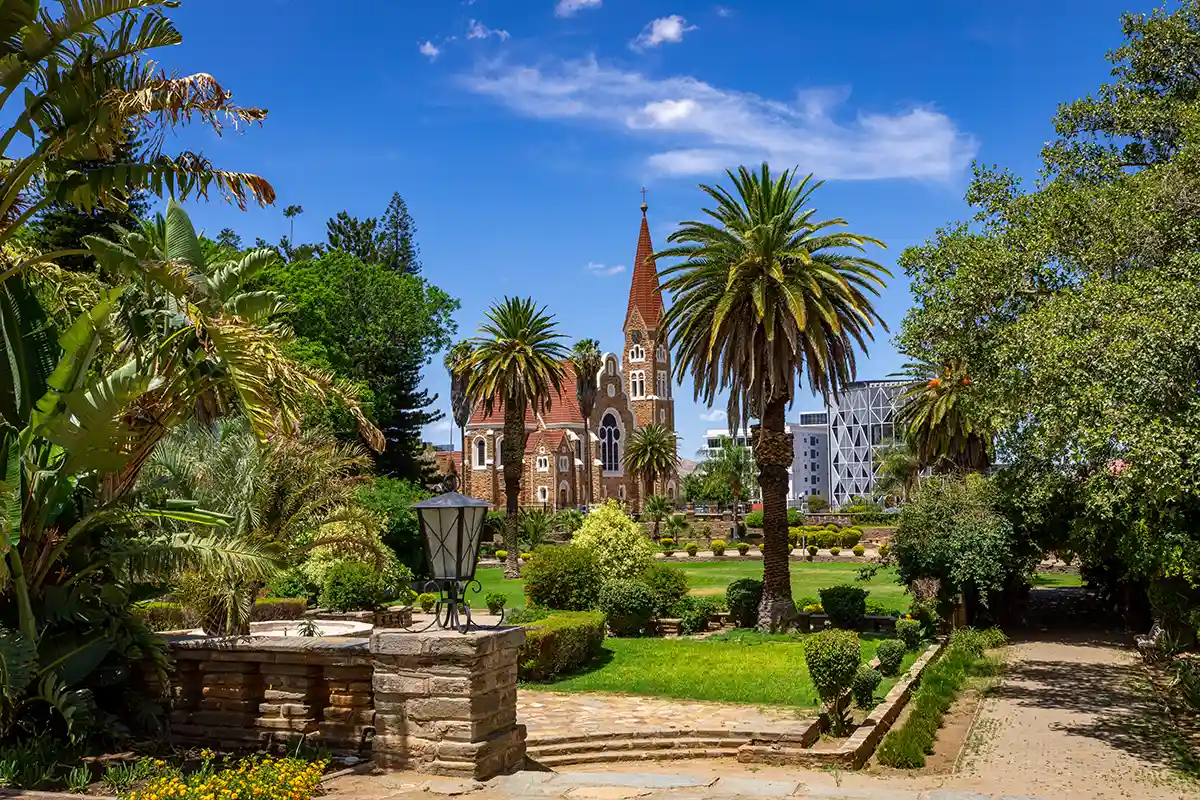
Windhoeks Christuskirche (1907–1910), det arkitektoniska kännetecknet för Khomas regionhuvudstad, sedd över de palmskuggade parlamentsträdgårdarna.
© Curioso Photography / Adobe Stock
Windhoek (≈ 480 000 in Greater Windhoek) is the demographic, political and economic centre of Khomas and of the country as a whole. It sits in a basin on the central plateau at 1 700 m and operates as the country's only proper city — every national institution, the only international airport with intercontinental traffic, every major hotel chain, the country's best restaurants, the central Namibian Craft Centre, and the start and end of nearly every self-drive itinerary in the country. The Wilhelmine architectural personality of the centre — Christuskirche, Alte Feste, Tintenpalast, the three Klein Windhoek castles — comes from the 1884–1915 German colonial period. The Independence Memorial Museum opened in 2014 on the hill behind the Alte Feste presents the country's pre-colonial, colonial and independence history across five floors. Klein Windhoek and Olympia hold the city's better restaurant scene — Joe's Beerhouse, The Stellenbosch Tasting Room, Leo's at the Castle in the Heinitzburg, Käpps in Swakopmund's Konditorei tradition. Katutura township on the city's western edge dates from a 1959 urban-restructuring period and today holds the demographic majority of the city; it is best explored on a guided township tour.
Daan Viljoen Game Reserve & the Khomas Hochland Game Farms
Daan Viljoen Game Reserve, 24 km west of central Windhoek on the C28 (the Bosua Pass road), is the closest National Park to the capital and the most reliable Khomas-area game stop. The 39 km² reserve sits in the Khomas Hochland and holds springbok, gemsbok, blue wildebeest, eland, giraffe, mountain zebra and kudu in a one-hour self-drive loop or on the marked Wag-'n-Bietjie hiking trail. The Sun Karros Daan Viljoen chalets and campsite are the in-park accommodation. Around Daan Viljoen and along the C26 and C28 corridors, the Khomas Hochland is dotted with private game farms and mountain lodges: Heja Lodge (in the Auas Mountains south of Windhoek), Eningu Clayhouse Lodge, the Olive Exclusive (closer to the city), Gocheganas (35 km south, Khomas Hochland views), Hilltop Guesthouse and the GocheGanas Wellness Village — these are the accessible 'first night in / last night before flying out' bases for travellers who want to be near Hosea Kutako Airport without overnighting in central Windhoek.
C26 & C28 — Khomas Hochland Gravel Passes
Two gravel routes run west across the Khomas Hochland from Windhoek to the Atlantic coast, both more scenic alternatives to the tarred B2. The C26 (via the Bosua Pass and the Gamsberg) is the more dramatic of the two — a 4–5 hour drive through the highest part of the Hochland, including the Gamsberg viewpoint at 2 347 m which on a clear day offers one of the country's most panoramic mountain-to-desert vistas. The road descends steeply down the Hochland's western escarpment via the Spreetshoogte Pass area (the steepest paved-and-gravel pass in Namibia, technically just south in Hardap) and across the Namib-Naukluft to the coast. The C28 (also via Daan Viljoen and the Bosua Pass, but a slightly different alignment) is the more direct alternative — also 4–5 hours, less dramatic at the top, but with the Goanikontes Oasis lunch stop in the lower Swakop riverbed. Both passes are gravel and best driven in a 4x4 or AWD; the C26 in particular has steep gradients that small sedans struggle with after rain. Self-drivers heading west who have time often choose one of these instead of the B2.
Auas Mountains, Avis Dam & Heja
The Auas Mountains south of Windhoek — a sub-range of the Khomas Hochland reaching the Aris Peak at 2 480 m — offer the city's nearest sustained walking and hiking. The Heja Lodge area on the M51 to the south is a private game farm with eland, hartebeest and mountain zebra in a 4 800-hectare reserve, plus marked walking trails and the Heja restaurant for hot-air-balloon-launch breakfasts. The Avis Dam on the eastern edge of the city — a small drinking-water reservoir built in 1933 — has become Windhoek's local cycling and birdwatching loop, with the 2-hour walking trail around the dam popular as a morning escape. The Klein Windhoek River walk between Eros Airport and the central business district is the city's pleasant short walking circuit. Aris (35 km south of the city on the B1) has a small hot-springs lodge — less developed than the better-known thermal springs at Gross Barmen south of Okahandja, but accessible as a half-day from the capital.
Hosea Kutako Airport & the B6 Eastward
Hosea Kutako International Airport (WDH), 45 km east of central Windhoek on the B6, is the country's only intercontinental gateway. It handles Lufthansa Discover from Frankfurt, Edelweiss from Zürich (launching three weekly from July 2026), Qatar Airways from Doha, Ethiopian from Addis Ababa, South African Airways and Airlink from Johannesburg and Cape Town, and seasonal charters. There is no rail link; transfers are by taxi (around N$ 500–600 one-way), pre-booked shuttle (cheaper, around N$ 250–350) or rental car. The B6 east of the airport continues to the Trans-Kalahari Border Post (Mamuno on the Botswana side) — one of the country's 10 Visa-on-Arrival entry points — and on to Gobabis (the Omaheke regional centre) and the Botswana border. The Khomas region's eastern edge is at the Gobabis turn-off, where the B6 leaves Khomas and enters the Omaheke region. The same airport serves as the country's main air-cargo gateway and the country's only proper duty-free shopping is in the airport's international departures area.
Heroes' Acre & the Southern B1
Heroes' Acre, 12 km south of central Windhoek on the B1, is the country's national-memorial garden — inaugurated in 2002 by then-President Sam Nujoma to commemorate the SWAPO independence movement (1966–1990) and the founding figures of independent Namibia. The memorial site, dominated by an obelisk and an unknown-soldier monument, hosts annual Heroes' Day commemorations on 26 August. The site is open to visitors and the access is free. South of Heroes' Acre, the B1 continues through the Khomas region toward Rehoboth (a Baster-community town in the Hardap region, 90 km south) and on to the Mariental–Keetmanshoop–South African border corridor. The B1 within Khomas itself is largely empty, with a few small commercial farms and game ranches and no settlements of size between Windhoek and the Hardap boundary.
Practical Khomas — Card Payment, Connectivity & Climate
Khomas has no urban public transport beyond Windhoek's informal taxis and Bolt (operating as Lefa). Every Khomas trip outside the city is a rental-car trip — typically a 4x4 collected at Hosea Kutako Airport. The B1 (north-south) and B6 (east) are tarred all the way; the B2 west is tarred to Swakopmund; the C26 and C28 west are gravel through the Khomas Hochland passes. Mobile coverage on MTC and Telecom Namibia is reliable throughout the city, on the B-roads and at the airport, intermittent on the C-roads of the Hochland interior. Card payment including contactless is universal in Windhoek; the smaller Hochland farm lodges sometimes prefer cash. ATMs are abundant in central Windhoek and at the airport — both N$ and ZAR work. The region operates almost entirely in English, with German widely spoken in the older central businesses, Afrikaans common as a second language, and Oshiwambo and Otjiherero widely heard in Katutura township.
Sätt att uppleva resmålet
Wilhelmine architecture, the Independence Memorial Museum, Joe's Beerhouse, the Namibia Craft Centre and the only proper restaurant-and-hotel scene in the country.
Daan Viljoen Game Reserve 24 km west of Windhoek with springbok, gemsbok, eland and giraffe; Gocheganas, Heja and the wider belt of private game farms in the Khomas highlands.
Scenic gravel descents from Windhoek to the Atlantic via the Bosua Pass and the Gamsberg viewpoint at 2 347 m — 4–5 hour drives that end at Swakopmund or Walvis Bay.
Namibia's only intercontinental airport 45 km east of the city; the B6 continues to the Trans-Kalahari Border Post (Mamuno) and on to Botswana — a Visa-on-Arrival entry point.
The Auas range south of Windhoek with hiking trails and the Heja game-farm reserve; the Avis Dam on the eastern edge of the city as the local cycling and birdwatching reservoir.
Heroes' Acre 12 km south of the city as the national-memorial garden; the Old Location Cemetery near Penduka as a small memorial site.
Khomas — Practical Travel Notes
- Greater Windhoek (≈ 480 000 people) is the only city of any size in Khomas and the only place in the country with consistent intercontinental flight access, full hotel chains, the central Namibia Craft Centre and a real restaurant scene. Outside Greater Windhoek the region is sparsely populated farm-and-game-ranch land.
- Hosea Kutako International Airport (WDH) is 45 km east of central Windhoek on the B6 — a 35–45 minute drive depending on traffic. No rail link. Transfer options: pre-booked shuttle (around N$ 250–350), fixed-rate taxi (around N$ 500–600), or rental car collected at the airport. The drive crosses the Auas–Onyati ridge with good summer afternoon views over the Hochland.
- Most international visitors collect their rental 4x4 at the airport rather than at a Windhoek city desk — the airport has all the major chains (Avis, Europcar, Bidvest, Asco, Drive Africa) with longer hours than the city offices. Inspect the spare tyre and the recovery gear (jack, wheel-nut wrench, recovery boards) before driving away.
- The Khomas Hochland gravel passes (C26 and C28) are dramatic but slow — allow 4–5 hours from Windhoek to the coast, and do not attempt the steep upper sections in a small sedan after rain. The Gamsberg viewpoint on the C26 at 2 347 m is one of the country's most panoramic mountain-to-desert overlooks.
- Daan Viljoen Game Reserve is open daily from 06:30 to 18:00 (gate closes at sunset); the entrance fee is paid at the gate (around N$ 80 adult). The loop drive takes about 90 minutes for a careful game-viewing pace. The Wag-'n-Bietjie hiking trail is well-marked and can be walked without a guide.
- Heroes' Acre, 12 km south on the B1, is open daily — access is free, but no shade or food is available on site, so visit in the early morning or late afternoon and bring water.
- Windhoek is safe by Southern-African standards in the day; walking the central streets after dark is discouraged in favour of taxis or Bolt/Lefa. Avoid Katutura township at night without a local guide; daytime township tours are well-organised and safe.
- Mobile coverage is reliable on the B-roads and at the airport; intermittent on the C-roads of the Hochland interior. Carry printed copies of bookings, the rental contract and emergency contacts for inland drives — do not rely on the phone screen at the moment you need a document.
- Card payment including contactless is universal in Windhoek and at the airport. Smaller Hochland farm lodges and the Spitzkoppe-area community sites take cash only. ATMs are abundant in central Windhoek (on Independence Avenue, in the Wernhil/Maerua/Town Square/The Grove malls) and at the airport — both N$ and ZAR work.
- Khomas's climate is mild and dry: 270+ days of sunshine, cool winter mornings (down to 5 °C in June and July at 1 700 m elevation), warm summer afternoons (28–32 °C from October to March) with afternoon thunderstorms in January and February. The region's altitude makes it noticeably cooler at night than the lower coast or southern desert.
- The region operates primarily in English (the official language) with German widely spoken in the older central businesses, Afrikaans common as a second language, and Oshiwambo and Otjiherero widely heard in Katutura township. International visitors find English universal in tourism, government and the airport.
- Sunday in Windhoek is quieter than weekdays — many smaller shops and some restaurants close, the malls remain open with reduced hours, and the Khomas Hochland game-farm restaurants generally open for lunch. Plan grocery shopping for Saturday afternoon if catering for a Sunday departure.
Transport och flygplatser
Turism och resmålsguider
National destination marketing organisation — trip-planning resources, registered-operator directories, festival calendar, and the e-Travel permit portal.
Bookings for the state-run rest camps inside the national parks. The Daan Viljoen camp in Khomas is run as a private concession, but the wider NWR network handles Etosha, Sossusvlei and the other state parks.
Städer i Khomas
Använd den här Visaja-sidan som utgångspunkt och kontrollera gällande regler direkt hos den officiella källan innan du ansöker.