Ciudad de México
Apply for your eVisa- Population:9.2M (2020)
- Area:1,485 km²
- Elevation:2,240 m
- Timezone:CT/CDT
- IATA:MEX
Overview
Ciudad de México (Mexico City) is the capital of Mexico and one of the largest urban areas in the Western Hemisphere — around 9.2 million people in the city proper and roughly 22 million across the metropolitan area. The city sits at 2,240 metres (7,350 ft) in the Valley of Mexico, built over the Aztec capital Tenochtitlán and the dry bed of Lake Texcoco, and concentrates the country's political life, its great muralist tradition, one of the world's flagship anthropology collections and the iconic Estadio Azteca, one of the largest football stadiums in the world and the home of Club América and the Mexican national team.
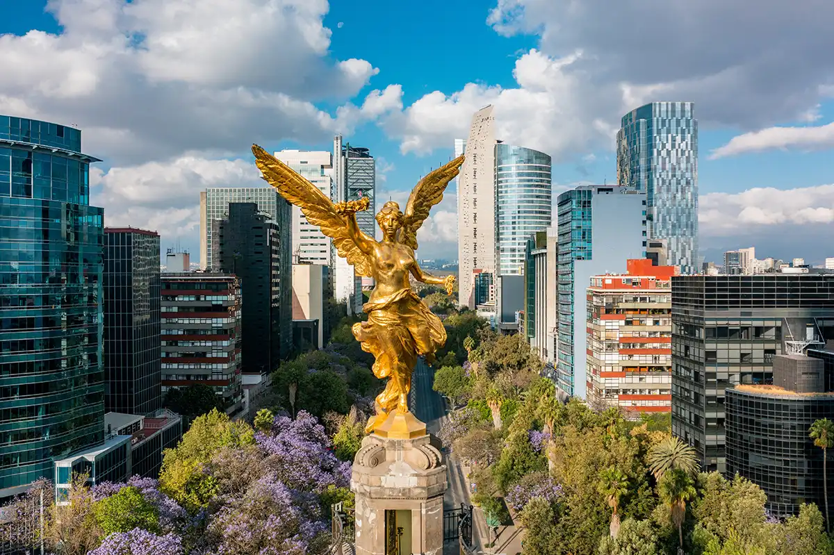
El Ángel — the golden victory column at the heart of Reforma.
© Alonso Reyes / Adobe Stock
Travel
Ciudad de México is the political and economic centre of Mexico and one of the largest urban areas in the Western Hemisphere — around 9.2 million people in the city proper and roughly 22 million across the metropolitan area. The city sits at 2,240 metres (7,350 ft) above sea level in the Valley of Mexico, ringed by mountains including the snow-capped Iztaccíhuatl and Popocatépetl volcanoes to the east; the modern urban grid is built over the Aztec capital Tenochtitlán and the dry bed of Lake Texcoco. That layered history is the city's defining feature: the UNESCO World Heritage Centro Histórico is built directly over the Aztec ceremonial centre, with the Templo Mayor excavation, the Catedral Metropolitana (the largest cathedral in the Americas) and the Palacio Nacional all framing the Zócalo, one of the largest public squares in the world. The neighbourhoods around the centre form a dense cultural geography: Roma and Condesa west of the centre with tree-lined streets, Art Nouveau and Art Deco apartment buildings, café culture and a modern restaurant scene; Polanco further west with the upscale Avenida Presidente Masaryk corridor and the Museo Soumaya and Museo Jumex collections; Coyoacán south of the centre with cobblestone streets and Frida Kahlo's Casa Azul; Xochimilco at the far south with its UNESCO-listed network of pre-Hispanic canals and trajinera flat-bottomed boats. Chapultepec Park — at 686 hectares one of the largest urban parks in the Western Hemisphere — concentrates many of the city's flagship institutions, including the Museo Nacional de Antropología (one of the great anthropology museums of the world), the Museo de Arte Moderno, the Museo Tamayo and the hilltop Chapultepec Castle. Diego Rivera and the Mexican muralist movement live in public buildings across the city — the Palacio Nacional, the Palacio de Bellas Artes, the Secretaría de Educación Pública and several smaller markets all carry mural cycles. Estadio Azteca, in the southern district of Santa Úrsula, is one of the largest stadiums in the world and the storied home of Club América and the Mexican national football team.
Centro Histórico and the Zócalo
The Centro Histórico, a UNESCO World Heritage site since 1987, sits directly over the centre of the Aztec capital Tenochtitlán and contains over 1,400 historic buildings across roughly nine square kilometres. The Zócalo — Plaza de la Constitución — is one of the largest public squares in the world, framed by the Catedral Metropolitana (the largest cathedral in the Americas, built from 1573 onward across multiple architectural styles), the Palacio Nacional with Diego Rivera's monumental mural cycle on the history of Mexico, and the Templo Mayor archaeological site exposing the Aztec ceremonial centre uncovered in 1978. Streets radiating from the Zócalo — Madero (pedestrianised, leading to Bellas Artes), Tacuba, Moneda and the Calle Donceles bookshop row — concentrate colonial-era civic and ecclesiastical architecture, hidden courtyards and museum entrances.
Palacio de Bellas Artes and the Alameda
The Palacio de Bellas Artes, a 1934-completed Art Nouveau exterior with an Art Deco interior, is the city's flagship performing-arts venue — home of the Ballet Folklórico de México and the national orchestra — and one of the most important houses of Mexican muralism: works by Rivera, Orozco, Siqueiros, Tamayo and O'Gorman line the upper galleries. The Alameda Central park immediately west — the oldest public park in the Americas, laid out in 1592 — frames the building and continues to the Museo Mural Diego Rivera, built specifically to house the artist's earthquake-damaged 'Sueño de una Tarde Dominical en la Alameda Central' fresco. The Torre Latinoamericana skyscraper directly south of Bellas Artes gives a high observation deck across the centre.
Roma, Condesa and the Restaurant Scene
Roma and Condesa, two adjacent neighbourhoods west of the centre, were laid out in the late 19th and early 20th centuries as planned upscale districts and now form the city's most established café and restaurant zone. Roma — split into Roma Norte and Roma Sur — carries Art Nouveau and Art Deco apartment buildings, gallery spaces, boutique hotels and an exceptionally dense concentration of new-Mexican and international restaurants. Condesa around Parque España and Parque México, with its Art Deco curving Avenida Amsterdam following a former racecourse, leans more toward parks, brunch culture and cycling. The two neighbourhoods anchor much of the city's contemporary creative economy and are the practical base for most first-time visitors.
Coyoacán, Frida Kahlo and San Ángel
Coyoacán, on the southern side of the city, was an independent colonial-era village until the early 20th century and still has a distinct cobblestone-and-courtyard fabric around its dual plazas (Jardín Hidalgo and Plaza de la Conchita). Frida Kahlo's Casa Azul on Calle Londres — the cobalt-blue house where the artist was born, lived with Diego Rivera and died — is the most visited cultural destination in the southern half of the city; advance ticket booking is essential. Leon Trotsky's house a few blocks away is preserved as a museum of his exile and 1940 assassination. The nearby San Ángel district carries the Saturday Bazar Sábado art market, the Museo Casa Estudio Diego Rivera y Frida Kahlo (Juan O'Gorman's paired studios) and one of the city's best-preserved colonial cores.
Chapultepec Park and the Museums of the West
Chapultepec Park, west of the centre, covers 686 hectares of mixed forest, lakes, formal gardens and institutional buildings — one of the largest urban parks in the Western Hemisphere. The park is split into three sections; the first is the most visited and contains the Museo Nacional de Antropología (one of the world's great anthropology museums, with the Aztec Sun Stone, the Mayan-room reconstruction of Pakal's tomb and the Toltec atlante figures), the Museo de Arte Moderno, the Museo Tamayo (international contemporary art) and the Chapultepec Castle on the hilltop — the only royal castle in North America to have housed a reigning sovereign. Polanco immediately west concentrates upscale shopping plus the Museo Soumaya (the Carlos Slim collection in its distinctive aluminum-tiled curved building) and the Museo Jumex contemporary art collection across the street.
Xochimilco, Teotihuacán and Day Trips
Xochimilco at the far southern edge of the city is the surviving fragment of the Aztec-era canal network — a UNESCO World Heritage Site since 1987 — where flat-bottomed brightly painted trajinera boats are still poled through the canals on weekends in a tradition unbroken since pre-Hispanic times. Northeast of the city, Teotihuacán — the pre-Aztec metropolis whose Pyramid of the Sun and Pyramid of the Moon flank the 2.5-kilometre Avenue of the Dead — is the country's most-visited archaeological site and a 1.5-hour drive from the centre. Puebla two hours southeast, Tepoztlán and Cuernavaca an hour south through the mountains, and the silver-mining colonial town of Taxco further south make practical overnight excursions.
Practical Mexico City — Metro, Airport and Altitude
The Mexico City Metro — twelve lines and 195 stations — is one of the largest and cheapest subway systems in the world, though peak-hour crowding is significant. The Metrobús bus-rapid-transit system on Insurgentes and other major axes is faster for some routes. The Ecobici bike-share network covers Roma, Condesa, Polanco, the centre and the Reforma corridor. Mexico City International Airport (MEX, Benito Juárez) remains the main hub; the newer Felipe Ángeles International Airport (NLU), opened in 2022 about 50 kilometres north, handles a growing share of domestic and some international traffic. The city's 2,240-metre altitude affects newly arrived visitors — slower walking pace, more water and less alcohol on day one are useful. Estadio Azteca in the southern district of Santa Úrsula — one of the largest stadiums in the world and the home of Club América and the Mexican national team — is reached from the centre by Tren Ligero light rail from Tasqueña or by car/rideshare via the Anillo Periférico ring road. Time zone: Central (CT/CDT).
Frequently asked questions
Is it true that Mexico City is sinking?
Is it true the Day of the Dead parade came from a James Bond film?
Why is the Estadio Azteca so historic?
How do I handle the altitude?
Which neighbourhoods should I stay in?
When should I visit — jacarandas or Day of the Dead?
Do I need a visa to visit Mexico City?
Tourism & destination guides
Culture & festivals
Official site of the National Museum of Anthropology in Chapultepec — home of the Aztec Sun Stone and one of the world's great archaeological collections.
Official site of Frida Kahlo's cobalt-blue house and museum in Coyoacán — tickets must be booked online in advance.
Diplomatic missions in Ciudad de México
13 embassies based in this city, grouped by region.
Europe5
Asia4
Americas3
Treat this Visaja page as your starting point: verify the current rules directly with the official source before you submit an application.