- Code:ER
- Type:region
- Native name:Erongo Region
- Population:150,809 (2011)
- Area:63,719 km²
- Capital:Swakopmund
Introduction
Erongo is the central-Namibian region on the country's Atlantic coast, named for the Erongo mountains — the eroded core of a volcano active some 132 million years ago, rising to 2 319 m at the Hohenstein and dominating the inland plateau between the coast and Damaraland. It spans some 64 000 km², reaching from the Kuiseb riverbed and the Hardap boundary in the south to the Ugab River — its border with Kunene and the southern edge of the Skeleton Coast Park — in the north, and inland along the B2 as far as Karibib and Usakos. The regional capital is Swakopmund.
Overview
Erongo is the region most travellers see first — the Atlantic coast, the dune sea and the granite inselbergs gathered into a few days' self-drive out of Windhoek. Base yourself in Swakopmund for the Wilhelmine seafront and the adventure scene, or in Walvis Bay just south for the flamingo lagoon and the wildlife on the water, then strike inland to Spitzkoppe and the Brandberg. It is the most-driven stretch of any Namibia trip, and most coastal days are spent here.
Discover Erongo
Swakopmund — the Wilhelmine Coastal Capital
Swakopmund is the region's centre and Namibia's principal coastal town. Founded in 1892 as the German South-West African port — a counterweight to British-controlled Walvis Bay 31 km south — the town retains an unusually dense Wilhelmine architectural layer: the Woermann House (1894), the Old District Court (Altes Amtsgericht, 1908), the Hohenzollernhaus (1906), the Marine Memorial (1908), the small Lutheran church (1911), and the lighthouse of 1903 (raised to its present height in 1910), all set on a thin strip of beach against the immediate edge of the Namib. The Mole — the original 1899 stone breakwater that silted closed within a decade — survives as the town's small lagoon and beach pool; the iron Jetty — begun in 1911 to replace the wooden landing pier of 1905, halted at 262 metres by the First World War and restored by 2010 — reaches into the Atlantic with the Jetty 1905 restaurant at its end. The Brewer & Butcher microbrewery in the Strand Hotel brews its beers on site, and Café Anton on Bismarck Strasse is the town's Wilhelmine-era coffeehouse. Most coastal Namibia itineraries spend two or three nights in Swakopmund as the natural pause-and-recovery between the inland safari leg and the southern desert leg.
Walvis Bay — Working Port & Wildlife on Water
Walvis Bay, 31 km south of Swakopmund on the C14, is Namibia's only deep-water port and the country's commercial gateway — bulk cargo, fuel, fish processing, and the start of the Trans-Kalahari and Trans-Caprivi corridors that ship Namibian and inland-African exports to the Atlantic. For the visitor, Walvis Bay is the better wildlife-on-water base: the lagoon's mudflats host enormous flamingo flocks from October to April; sea kayaking from the yacht club paddles through bottlenose-dolphin pods to the Cape fur seal colony at Pelican Point in a 4-hour morning; sunset catamaran cruises with Catamaran Charters or Mola Mola run shorter sailings to the Pelican Point lighthouse. The Sandwich Harbour 4x4 day tour drives south from Walvis Bay into the Namib-Naukluft to the freshwater lagoon at Sandwich Harbour, where dunes plunge directly into the Atlantic. The Bird Paradise sewage-treatment ponds north of the town belong to the Walvis Bay wetlands, a Ramsar site and southern Africa's most important coastal wetland for birds, with more than 150 species recorded. Walvis Bay Airport (WVB) is the regional commercial airport — closer to most Erongo destinations than Hosea Kutako, with FlyNamibia services to Windhoek and the safari destinations.
Spitzkoppe — the Matterhorn of Namibia
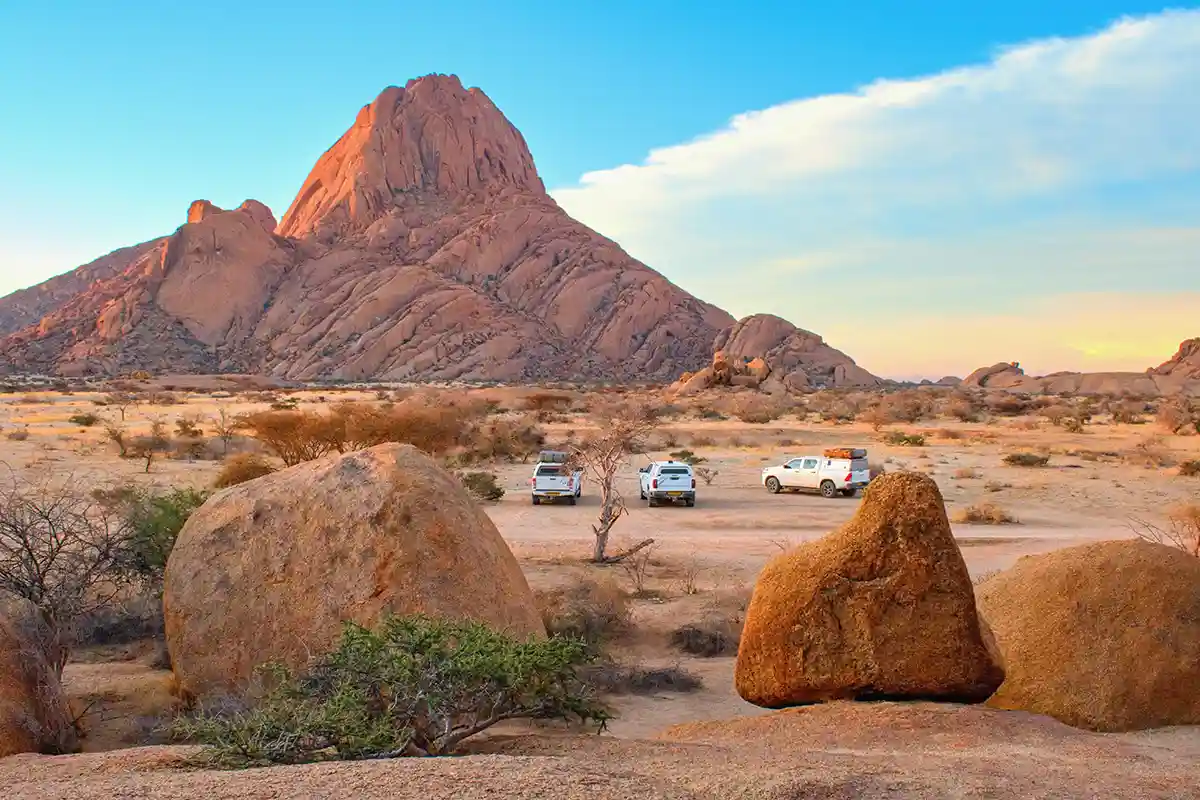
Spitzkoppe at golden hour. The community-run conservancy charges a modest day fee and rents simple campsites among the boulders.
© Tunatura / Adobe Stock
Spitzkoppe, two hours west of Usakos on the C36, is a 1 728-metre granite inselberg that rises some 670 metres straight out of the gravel plain — one of the country's most distinctive natural landmarks and the visual icon used in almost every Namibia travel marketing campaign. The community-run ≠Gaingu Conservancy below the mountain charges a modest day fee and offers some of the best-value camping in southern Africa: pit toilets, no electricity, but each site is hidden in its own granite outcrop with views straight across the plain. Climbing the main Spitzkoppe peak requires a guide and roping-up gear and is undertaken by experienced parties only; the Pondok hike (an easier route into the smaller granite domes north of the main peak) is a marked half-day walk with rock art at the Bushman's Paradise overhang. The Spitzkoppe rock-pool circuit at the eastern base is an easy 90-minute loop. Sunrise and sunset both light the granite an extraordinary orange. The conservancy's restaurant serves simple meals; the bookable rest camp (the Spitzkoppe Lodge) is a few kilometres east.
Brandberg, White Lady & the Erongo Mountain
The Brandberg massif north of Uis is Namibia's highest mountain — the Königstein at 2 573 m — and a UNESCO Tentative-List site for its dense concentration of San rock art. The White Lady painting in the Maack Shelter at Tsisab Gorge — named after the surveyor Reinhard Maack, who recorded it in 1917 — is the best-known piece, reached on a guided walk of roughly 40 to 60 minutes each way from the car park (a registered Damara guide is mandatory and included in the entry fee); further painted rock faces line the path up the gorge. The Brandberg's western slopes face the dune coast and the cold Benguela air; the eastern slopes face the hot inland plateau, creating a microclimate that supports rare endemics including the Brandberg gecko and the Brandberg-acacia. South of the Brandberg, the Erongo mountains themselves (the volcanic massif that gives the region its name) rise to 2 319 m at the Hohenstein, with extensive walking trails, rock-art shelters and the Erongo Wilderness Lodge as the central base for guided walks. Uis is the small mining town between the Brandberg and the inland — its tin mine, closed in 1990, has been back in production since 2019; the town has fuel, a small supermarket and a couple of lodges as the natural base for Brandberg day trips.
Cape Cross, the C34 & the Southern Skeleton Coast
Cape Cross, 120 km north of Swakopmund on the gravel C34, holds the largest Cape fur seal colony on the southern-African Atlantic coast — between 100 000 and 200 000 animals depending on the season, with the breeding peak in November and December. The Portuguese padrão (stone pillar) marking the headland was erected by Diogo Cão in 1486 at the southernmost point his voyages reached; the Imperial German Navy took the original to Berlin at the end of the 19th century, and it was returned to Namibia in 2019 — the headland itself holds replicas. The C34 north of Cape Cross continues into the Skeleton Coast Park — the Ugab Gate marks the official entry to the park, the Zeila shipwreck (a 2008-stranded fishing trawler just south of Henties Bay) is the most-photographed of the coast's many wrecks, and Terrace Bay (with the NWR rest camp) is the park's year-round place to stay. The southern Skeleton Coast between Swakopmund and Möwe Bay is driveable with a permit (sold at the park gate); the northern Skeleton Coast above Möwe Bay is fly-in only with the lodge operators (Shipwreck Lodge, Hoanib Skeleton Coast Camp).
The B2 Corridor — Usakos, Karibib & the Welwitschia Drive
The B2 tarred highway from Windhoek to Swakopmund and Walvis Bay is the region's main spine. Usakos (3 500 people, on the B2 at the C36 turn-off to Spitzkoppe) is a small railway-and-mining town that grew around the original 1890s narrow-gauge railway repair workshops; today it is the obligatory fuel-and-snack stop for travellers heading to Spitzkoppe. Karibib (5 500 people, 30 km east on the B2) is a small mining town known for its marble — Karibib marble has been quarried here for more than a century — and for the Navachab gold mine nearby. The Welwitschia Drive in the Namib-Naukluft east of Swakopmund is one of the region's distinctive half-day or full-day loops — about 130 km through the Moon Landscape (hills and canyons the Swakop River has cut through granite and schist) and across stands of Welwitschia mirabilis, the two-leaved desert gymnosperm whose oldest plants are more than 2 000 years old. Permits are sold at the Namib-Naukluft office or the Namib-i visitor centre in Swakopmund. The Goanikontes Oasis at the Swakop riverbed crossing makes a pleasant lunch stop on the drive.
Practical Erongo — Climate, Connectivity & Where to Stay
Erongo's coastal climate is unique within Namibia. The cold Benguela Current keeps Swakopmund and Walvis Bay between 15 and 22 °C even in summer, with fog rolling in at night for much of the year — December and January are the only consistently warm coastal months. The inland Erongo (Usakos, Karibib, Spitzkoppe) is hot (often 35–40 °C in summer afternoons) and dry, with cold winter nights below freezing in June and July. Connectivity is good in the towns — MTC and Telecom Namibia have solid 4G coverage in Swakopmund and Walvis Bay, intermittent on the B2, and patchy on the gravel C-roads. Card payment including contactless is universal in the towns; small craft stalls and the Spitzkoppe conservancy take cash only. The Strand Hotel, the Hansa Hotel and the Sea Side Hotel & Spa in Swakopmund are the central-Wilhelmine choices; the Lagoon Lodge and the Pelican Bay Hotel in Walvis Bay overlook the lagoon; the Spitzkoppe Lodge and the Erongo Wilderness Lodge are the regional inland base lodges; the Cape Cross Lodge and Terrace Bay (NWR) hold the northern coastal stops.
Ways to Experience This Destination
Half-timbered architecture, Café Anton, the Brewer & Butcher microbrewery, sandboarding, dune quad-biking, skydiving over the Namib and the Sandwich Harbour 4x4 day trip — the country's coastal-adventure capital.
Lagoon flamingo flocks from October to April, kayaking with bottlenose dolphins and Cape fur seals at Pelican Point, sunset catamaran cruises, Bird Paradise sewage lagoon, and Walvis Bay Airport as the regional commercial gateway.
1 728-metre granite massif west of Usakos with the community-conservancy campsite among the boulders, the Pondok hike, the Bushman's Paradise rock art and the orange sunset light on the granite.
Namibia's highest peak (Königstein 2 573 m), the White Lady rock painting in the Maack Shelter at Tsisab Gorge with a mandatory Damara guide, and the Brandberg's microclimate endemics.
Cape Cross Cape fur seal colony (100 000+ animals), the 1486 Portuguese padrão of Diogo Cão, the Zeila shipwreck south of Henties Bay, the Ugab Gate entry to the Skeleton Coast Park and Terrace Bay as the southernmost stay.
The 130-km Namib-Naukluft loop east of Swakopmund through the Moon Landscape and the Welwitschia stands; four-hour Living Desert tours into the dunes for sidewinder snakes, Namaqua chameleons and fog-basking beetles.
Frequently asked questions
What's the difference between Swakopmund and Walvis Bay?
Do I need a 4x4 to visit Spitzkoppe or Cape Cross?
How many days should I plan for the Erongo coast?
Can I visit Cape Cross and the Skeleton Coast as a day trip from Swakopmund?
When is the best time to visit the Erongo coast given the fog?
Which airport is closest to the Erongo coast?
Do I need permits or guides for Spitzkoppe and the White Lady?
What languages will I hear in the Erongo region?
Can I combine Erongo with Damaraland?
Tourism & destination guides
National destination marketing organisation — trip-planning resources, registered-operator directories, festival calendar, and the e-Travel permit portal.
Town-level tourism portal with activity directories, event calendar, accommodation listings and the practical visitor information for the regional capital.
State-run rest-camp bookings — Terrace Bay in the Skeleton Coast Park, the Namib-Naukluft rest camps, and the wider NWR network across the country. Books up to 11 months ahead.
The community-run conservancy at the foot of the Spitzkoppe — campsite reservations, day-fees, the Pondok hike and the rock-art sites at Bushman's Paradise.
Cities in Erongo
This overview comes from Visaja's worldwide missions database (visaja.com), checked against official government sources; for binding answers, the mission itself always has the final word.